Oat Hill Mine Trail
![]()
The Northern Section of the Oat Hill Mine Trail (Between the Palisades Trail junction at Holm’s Place and the Aetna Springs Trailhead) is closed 8/8/26-9/20/26.
The northern section of the Oat Hill Mine Trail is closed during this period for two reasons:
~ High Risk of Wildfire: There is almost no cell reception, and this segment of trail is extremely remote. Evacuation and rescue is difficult on this section of trail.
~ Hunting Season: Deer hunting season is open during this time period and this trail passes through private properties that allow hunting.
Activities: Hiking, Mountain Biking, Equestrian Use, Wildlife Viewing
Location: Main Parking Area 2082 Oat Hill Mine Trail, Calistoga, CA 94515 Google Map /Aetna Springs Trailhead, Aetna Springs Rd, Pope Valley, CA 94567 Google Map
Hours: Sunrise to sunset.
Fees & Details: There are no fees at Oat Hill Mine Trail. All trails are multi-use.
Amenities: Small parking lot for all size vehicles. There is no potable water available at the park.
Park Rules: Please respect private property and do not trespass. Observe park boundary signs and stay on NOSD property at all times. No hunting or shooting allowed on this trail. Dogs are allowed and must be under voice command at all times.
Maps and Park Notes: Oat Hill Mine Trail Brochure, Oat Hill Mine Trail Poster Map
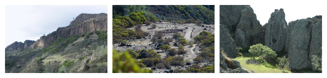
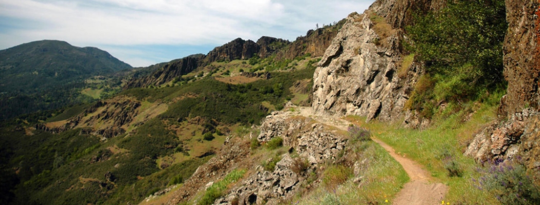
The Oat Hill Mine Trail follows 8.3 miles of an old stage coach route between Calistoga and the western end of Aetna Springs Road in Pope Valley over an elevation change of 1500 feet. The trail can be divided with the halfway point at the base of the Palisades (Holms Place) with a return to Calistoga or on to Pope Valley.
The trail provides a magnificent recreational experience for hikers, mountain bicyclists and equestrians. This is a challenging trail and can be very rough and rocky along the way. Visitors can enjoy sweeping views of Napa Valley along the lower Oat Hill Mine Trail, while the middle and upper sections of the trail cross striking volcanic formations. The journey passes through a diverse mixture of Oak, Douglas Fir, Gray Pine and Cypress forests, chaparral, and grasslands. Spring wildflowers are exceptional.
Note: because of the length of the trail, shuttling with two cars is recommended if you are traveling all the way through to Pope Valley. The drive time between trailheads is approximately 1 hour each way by car.
History of the Oat Hill Mine Trail
 Construction of the Oat Hill Mine Road was started in 1873 to provide a transportation route between Calistoga and the cinnabar and quicksilver (mercury) mines. It took 20 years to complete the project and the road was officially opened in 1893, connecting Calistoga to the Oat Hill Mine with a side branch descending to Aetna Springs.
Today the 8.3-mile-long Oat Hill Mine Trail follows the original route between Calistoga and the western end of Aetna Springs Road in Pope Valley. The old mercury mines are further to the north, and are not open to the public.
Midway along the trail is the homestead property of Karl Gustov Holm, who built a log cabin on his 160-acre homestead in 1893, and added a new house in 1896. Parts of stone wall for his barn and a few old fruit trees remain today.
Ruts carved by heavy wagons traversing the soft volcanic rock are still visible along parts of the middle and upper trail. Hand-laid stone walls are visible at many locations along the trail.
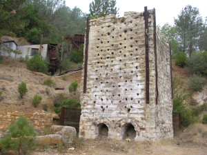
The photo above is of a historic mercury kiln at the Corona Mine near the Oat Hill Mine. Please note that this kiln is located on private property and is not accessible from the Oat Hill Mine Trail.
Additional Oat Hill Mine Trail Information and Articles:
Trailside Geology of the Oat Hill Road (Dean Enderlin, March 1995)
Napa Open Space 3rd Saturday Hike/Bike (Video clip of a mountain bike ride on OHMT)
The Oat Hill Mine Trail in Napa County (The Four Seasons, Journal of the Regional Parks Botanic Gardens, Volume 11, Number 3)