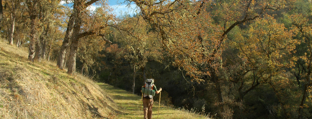
Napa County offers up beautiful vistas and some rugged & wild terrain and there are several areas that provide options for backpacking and longer trips than a day hike.
We’ve listed the most common options for backpackers below along with links to the managing agencies for each. Please visit the websites of these agencies and/or contact them for any details about these properties and permitting/rules.
Berryessa Vista Wilderness Park
 Activities: Hiking, fishing, primitive camping,
Details: There are no fees, no reservations and availability is on a first-come, first-serve basis. There is no potable water at the site (bring your own drinking water).
Fires: No open fires.
Note: Camping/overnight stays at Berryessa Vista must be arranged in advance so that your car does not get ticketed or towed.
Directions:
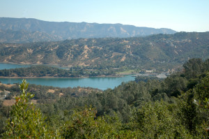
The Napa Open Space District allows backpacking and backcountry camping at Berryessa Vista Wilderness Park, a 224-acre park accessible by boat from Lake Berryessa. There are numerous dirt tracks leading from the edge of the lake up into and through the park. The closest boat launch is Capell Cove. Please see our map here for directions.
Sweeping views of Lake Berryessa, Berryessa Peak, and the surrounding countryside can be had from various locations. The terrain is generally steep and the vegetation is a diverse mixture of Oaks Woodland, Gray Pine Forest, and Chaparral.
Berryessa Peak Trail
 Activities: Hiking, primitive camping,
Details: There are no fees, no reservations and availability is on a first-come, first-serve basis. There is no potable water at the site (bring your own drinking water).
Fires: Campfires are allowed only on BLM land.
Note: This is a very challenging hike. Please see the full Berryessa Peak Trail page for hike notes.
Directions: Berryessa Knoxville Rd, Napa (Google Map here). Berryessa Knoxville Road at mile marker 20.00 (East side of the road). More detail about the trailhead and hike is in the link above.
This eight mile (sixteen mile round trip) hiking trail, made possible with the donation of a trail easement by a local ranching family, provides public access to several thousand acres of otherwise shut-off public lands owned by the federal government. The trail offers dramatic views of the Sierra Nevada Mountains to the east, Mt. St. Helena and the Mayacamas Range to the west, Snow Mountain to the north, and Mt. Diablo to the south.
One of the more challenging hikes in Napa County, this trail climbs 3,500 feet to Berryessa Peak with beautiful scenic views along the way. Please see the main trail page here before planning this hike for a detailed description.
Other backpacking options are on Bureau of Land Management (BLM) properties.
To learn more about these areas, check out our map and on the left, scroll down and click ‘stewards’ and select Bureau of Land Management – California. Click on Areas and you will see the three properties listed below.
Please note that there is little to no signage in most of the areas listed below. Hikers and backpackers entering these areas must be skilled at map reading and route-finding.
Knoxville Recreation Area
 Activities: Hiking, mountain biking, hunting, fishing, primitive camping, Off Highway Vehicles (OHV)
Details: There are no fees, no reservations and availability is on a first-come, first-serve basis. There is no potable water at the site (bring your own drinking water).
Firewood Gathering: Cutting or removing standing vegetation (live or dead), is strictly prohibited. Use only wood that is both dead and down for firewood.
Note: There is little to no signage in this area. Hikers and backpackers entering this area must be skilled at map reading and route-finding.
Directions:
– From Napa, take the Lake Berryessa Road (hugs the west side of the lake). After crossing Putah Creek, it is approximately 17 miles to the Devilhead Road entrance, and 20 miles to the Dunnigan Hill Road entrance.
– From St. Helena, take Pope Valley Road to Pope Creek Road. Take a left at the Lake Berryessa-Knoxville Road. It is approximately 17 miles to the Devilhead Road entrance, and 20 miles to the Dunnigan Hill Road entrance.
– From the town of Lower Lake go east on Morgan Valley Road 13 miles to the north entrance to Knoxville at Dunnigan Hill Road (this access not recommended for two-wheel drive vehicles beyond Round Mountain Road). Continue three miles further on Morgan Valley Road for the south entrance to Knoxville at the intersection with Devilhead Road (southeast of the McLaughlin Mine crushing plant). There are BLM signs at both entrances.
CAUTION: There are 4-5 lower water crossings located on the Lake Berryessa-Knoxville Road north of Lake Berryessa that may restrict access to the Knoxville entrances from the south.
– Camping is available at Lower Hunting Creek, located at the intersection of Dunnigan Hill Road and Hunting Creek Road at Hunting Creek. This developed campground has 5 sites with shade structures, vault toilet, trash cans, and 3 overflow campsites.
– Cedar Creek, Cement Creek, and Pocock Creek are primitive camps with no facilities.
Due to its close proximity to the Sacramento and San Francisco Bay Area regions, and because of its varied terrain, Knoxville’s 17,700 acres attract many off-highway vehicle (OHV) enthusiasts each year. The landscape is characterized by steep and rolling hills with the vegetation varying from scattered hardwoods and grasses to dense chaparral brush. California gray pine and Macnab cypress are also dispersed throughout the area. Of particular note, are unusual plant communities unique to the area’s serpentine barrens, which are closed to vehicles to protect the delicate vegetation.
Other popular activities in the area include hunting, mountain bicycling, camping, and nature study. There is one developed campground, and an OHV staging area.
Cedar Roughs Wilderness
Activities: Hiking, hunting, fishing, primitive camping
Details: There are no fees, no reservations and availability is on a first-come, first-serve basis. Primitive camping is best experienced October to May. As hunting is allowed, please be aware of deer, dove and turkey season.
Firewood Gathering: Cutting or removing standing vegetation (live or dead), is strictly prohibited. Use only wood that is both dead and down for firewood.
Note: There is little to no signage in this area and no formal trail system. Hikers and backpackers entering this area must be skilled at map reading and route-finding.
Directions:
– From Rutherford take Highway 128 east. Turn left on Chiles Pope Valley for several miles to Pope Canyon Road.
– From Winters take Highway 128 west. Turn right on Lower Chiles Valley Road, then right on Chiles Pope Valley Road for several miles to Pope Canyon Road.
– The two parcels lie 2.2 miles and 4.2 miles west of Pope Creek bridge (Lake Berryessa and Maxwell Creek units, respectively).
The Cedar Roughs Wildlife Area consists of two separate parcels, the Lake Berryessa and Maxwell Creek units, totaling 414 acres of brush-covered canyons, serpentine grasslands, oak woodlands, and riparian habitats. Access to both parcels requires crossing Pope Creek by foot, which is only possible during the dry season.
The Lake Berryessa Unit provides access to the 6,350 acres of BLM’s Cedar Roughs Wilderness Area. The Maxwell Creek Unit provides access to an additional 160 acres of BLM land that was previously surrounded by private land, via Pope Canyon Road at the confluence of Maxwell Creek with Pope Creek.
The Cedar Roughs Wilderness is home to the world’s largest, genetically pure stand of Sargent cypress, however due to the remote nature of the area, there isn’t an established trail to the stand.
Maple Springs
(Listed as Oat Hill Mine Trail Section, BLM)
Activities: Hiking, mountain biking, primitive camping
Details: There are no fees, no reservations and availability is on a first-come, first-serve basis. Maple Springs can often provide water, but it must be purified prior to use; otherwise there are no facilities.
Firewood Gathering: Cutting or removing standing vegetation (live or dead), is strictly prohibited. Use only wood that is both dead and down for firewood.
Note: There is little to no signage in this area. Hikers and backpackers entering this area must be skilled at map reading and route-finding.
Maple Springs is a small 39 acre parcel located adjacent to Robert Louis Stevenson State Park.
The parcel is located approximately 5 miles up Oat Hill Mine Trail.